Thursday, 12 January 2012

REFERENCE MAPS

Geographic Extent of Information


The Atlas of Human Activities contains information on the Fisheries and Oceans Canada (DFO) administrative region known as the Maritimes Region. This area includes the Scotian Shelf and adjacent slope to the full extent of Canada's 200-nautical mile exclusive economic zone, as well as the Bay of Fundy and Canadian portions of the Gulf of Maine and Georges Bank. Within DFO, the area is also known as the Scotia-Fundy Fisheries Management Region.

This map is intended to be a reference for the rest of the document. It shows the boundaries for most of the information collected for the atlas: the regional boundary, composed of the international and exclusive economic zone boundaries and the division between the Maritimes region of DFO and the Newfoundland and Gulf regions. 

The latter is also the eastern boundary of the Eastern Scotian Shelf Integrated Management (ESSIM) initiative. In a few cases, we have included information from outside this area, reflecting the management boundaries used by other government departments and agencies that are active in the area. Those administrative boundaries are shown where relevant.

The inset map shows the location of the Scotian Shelf in relation to North America and the North Atlantic Ocean. The image is a composite of multiple satellite images taken in 1996 by NOAA (National Oceanic and Atmospheric Administration) weather satellites and enhanced with digital elevation data.


Legend

Geographic Extent of Information


Topography and Geographic Names


 The shape of the ocean floor influences the physical and biological marine environment, from the speed and direction of currents flowing over the ocean bottom to the distribution of marine plants and animals. This in turn influences the human activities that occur in the area. The present seafloor topography of the Scotian Shelf, Gulf of Maine and the Bay of Fundy is the result of many thousands of years of geological processes.


Compared to many other submerged continental shelf areas, the Scotian Shelf is relatively wide and extends from 125 to 230 kilometres offshore. At the shelf edge, at about 200 metres in depth, the ocean floor becomes steeper. The area from the edge of the shelf to 2000 metres in depth is known as the "slope" or Scotian Slope. From about 2000 to 5000 metres in depth, the change in depth becomes more gradual. This area is known as the "rise." Several large submarine canyons indent the outer shelf, slope, and rise, and some smaller valleys also cross the slope and rise.

Although the shelf itself is relatively flat compared with the slope, there are still many obvious features. There are broad, relatively shallow and flat bank areas, and deeper areas known as basins. Two large channels - the Northeast Channel and Laurentian Channel - divide the Scotian Shelf from Georges Bank and the Newfoundland Shelf respectively. Several deep basins, such as Jordan Basin, are the notable topographic features of the Gulf of Maine.

Geographic Names

The geographic names for undersea features originate from many different sources, including the physical characteristics of the area, names used by First Nations or from First Nation languages, names of nearby features on land, and the religious beliefs of early European explorers. For example, Sable Island Bank is named for its prominent feature, the long, sandy Sable Island. The island in turn gets its name from the French word for sand, "sable." Georges Bank was named after St. George and references to "St. Georges Bank" continued into the twentieth century . 

Since the late 1960s, the Advisory Committee on Names for Undersea and Maritime Features has made recommendations to the Geographical Names Board of Canada on authoritative names for undersea features within Canada's jurisdiction (CPCGN 1988, NRCAN 2005). The standardized names are shown on the map opposite; however, different names may be in use in some areas or among certain marine users.

Legend

Topography and Geographic Names

Monday, 9 January 2012

BIOLOGICAL FEATURES

Plants


Plant growth on beaches is limited to a few species. The plants that are able to grow here either need protection in the dunes from the harsh forces of the wind, or they have to be very well-adapted to the shifting sand, temperature, salt, and limited water supply. In general, you'll see very distinct zones on a beach.

Zonation of plants on the backshore

Zonation of plants on the backshore

Filamentous algae can be found in great numbers on the mud exposed at low tide. Seaweed is a type of algae and there are many different ones to discover. It is often found on the beach, washed ashore by the waves. The sand below the low tide line is too unstable and the water too turbulent for seaweed to grow. 

As a result, these plants grow in the subtidal zone below the low tide limit, where a more stable substrate is available. You can gather seaweed on the shore. It can be used as a source of food or for plant study. Sandy beaches support productive and diverse micro-algal communities of species that are adapted to moving sand. They live between sand grains or attached to them.


Bayberry
Bayberry (Myrica pensylvanica)
Bayberry grows in the protection of the dunes. This shrub is also called Candle Berry. It contains a resin, which was used in candle making in earlier times.

wild rose
wild rose (Rosa sp.) 

 Beachgrass

Beachgrass or Marram Grass (Ammophilia breviligulata) is the most important plant on the beach. It stabilizes the shifting sand and prepares it for further plant colonization. You'll see it mostly in the foredune where conditions are most severe. Sea Lyme-Grass (Elymus arenarius) can be found growing with Beachgrass, and it also grows in coarser sand and sometimes even gravel. This grass can also be found in salt marshes, where the sand is mixed with mud.

Ammophilia comes from ammos (Greek for sand) and philos (Greek for loving). Beachgrass has to be covered by at least seven centimetres of sand over the year to be able to survive. Its rhizomes trap the sand like a very fine-meshed net. The amount of sand coverage stimulates the growth of Beachgrass. The grass sends out runners to cover more area. The dead plant material in the sand, the living rhizomes, and the living plants on the surface very effectively trap the sand and create a more stable environment. Beachgrass receives some nutrients from the salt spray.

Molluscs


In the beach ecosystem molluscs are found on the sandbars and mudflats. Some molluscs feed by filtering water for tiny sources of food such as plankton and others are carnivores. Some will graze on microscopic algae. Others feed on detritus from dead animals and plants. They are an important source of food for other species such as fish and birds.

How do clams bury themselves?

A Clam buries itself by extending its foot in a tapered point into the sand. Then the foot expands and becomes an anchor. The clam pulls the rest of the body downward.

Different feeding techniques of clams

Different feeding techniques of clams


Common Northern Moon Shell

Common Northern Moon Shell (Lunatia heros)

The Common Northern Moon Shell is a carnivore whose shells and sand collars can often be found on the beach. 10 cm.

Razor Clam
Razor Clam (Ensis directus)

The Common Northern Moon Shell

The Common Northern Moon Shell lives just below the water's surface, in low intertidal and subtidal zones. Moon shell egg masses can be found on the beach in summer. Sand collars protect the eggs from predators. Moon shells are predatory and eat clams and worms. They bore holes in clam shells with a 'radula,' which acts like a drill. A radula is the 'tongue' of molluscs, a horny strip that is continually renewed and has teeth on its surface.


Where moon shells are common, the number of worms and molluscs may decrease.
 
Sand collarSand collar


Insects


Rarely are we disturbed by biting insects on the beach. They're usually kept away by the wind. But when the wind stops blowing, mosquitoes from salt marshes, horse flies, and deer flies can become a nuisance. Small flies feed on the detritus of the strand line and are in turn food for other creatures such as birds and shrews. Robins and warblers can be seen feeding on these insects. Ants and spiders live in the dunes and the holes of sandwasps can often be observed in the sand.

Short-tailed Black Swallowtail
Short-tailed Black Swallowtail (Black butterflie)

The Short-tailed Black Swallowtail is a common butterfly in the dunes. Its caterpillars feed on the leaves of Scotch Lovage and develop into large, black butterflies with yellow and white spots.

Crustaceans


Crustaceans are a familiar group of organisms. Most of them are edible and quite visible in the sand, debris, and the water.

Sand Shrimp
Sand Shrimp (Crangon septemspinosa)

Sand Shrimps are lower shore carnivores that can be found at the seaweed, digging into the sand. They are about 9.9 mm long when mature.

amphipod
amphipod
Some amphipods get thrown up by waves and then feed on detritus. They dive back into the protection of the sand when the waves recede. Beach hoppers live in this zone and are around 3 cm large.

Rock Crab
Rock Crab (Cancer irroratus)

This common crab washes up on the beach or is caught in lobster traps. It feeds on dead animals but will also eat any live prey it can catch. To 13.1 cm.

Echinoderms


Sand Dollar
Sand Dollar (Echinarachnius parma)
The Sand Dollar mainly eats microscopic algae that are found in the sand. To 7.5 cm.

Worms


Marine worms occur in the intertidal zone. Some are carnivores, while others eat seaweed or detritus (non-living materials). Marine worms put organic matter back into circulation. They also provide food for a great variety of animals such as crustaceans, fish, and birds.
red-lined worm
red-lined worm (Nephtys sp.)

Fish


From the beach you can observe some species of flounders, Capelin, Atlantic Silverside and the American Sand Lance. Sand Lances are an important food source for Cod, Haddock, Pollock, Plaice, and Yellowtail Flounder. Winter Flounder are an important food source for seals, Osprey, Great Blue Heron, and cormorants. Capelin feed on plankton. Many bird species, fish, and marine mammals feed on capelin. The Atlantic Cod is presumed to be a main predator. Minke Whales and Fin Whales also feed extensively on Capelin.

American Sand Lance
American Sand Lance (Ammodytes americanus)

The American Sand Lance is a small fish that can burrow several inches deep into the bottom above the low tide level. They can be observed looking out of their holes from time to time, perhaps verifying whether the water is coming back. They primarily feed on copepods, but also to a lesser extent on snails, worms, etc. To 15 cm.

Smooth Flounder
Smooth Flounder (Liopsetta putnami)

The Smooth Flounder is the smallest of flounders and is found mainly in estuaries. It feeds on copepods, small shrimp, crabs, molluscs, etc. To 32.3 cm.

Winter Flounder
Winter Flounder (Pseudopleuronectus americanus)


Birds


Few birds use the beach for nesting. Among these are the Piping Plover, a small endangered bird. Horned Lark and Spotted Sandpiper, the Common Tern, Red-breasted Merganser, and several species of gulls make their nests in the grass of the dunes, where as the Piping Plover uses a shallow depression in the sand as a nest.

Horned Lark

The genus name of the Horned Lark, 'Eremphila,' means desert-loving. They prefer to nest in the dry upper reaches of the beach. This species is also known for its courtship displays. The bird will suddenly rise silently very high in the air where it will begin a high-pitched tinkling song as it circles for 15-20 minutes at a time. Then suddenly it drops to the ground with its wings closed. They breed on the northeast coast of New Brunswick and some winter along the coast of Nova Scotia while others fly farther south.

Some birds' habitat and food
BirdHabitatFood
Piping Plover beach, sandflats, mudflats marine worms, shore flies, beach hoppers, microscopic crustaceans
Semipalmated Plover beach, sandflats, mudflats; abundant migrant; breeds in the Arctic and locally on dark cobble beaches in Eastern Canada marine worms, small molluscs, small crustaceans, eggs of marine animals, insects
Semipalmated Sandpiper nest in Arctic Tundra; abundant migrant; beaches, intertidal area periwinkles, marine worms, amphipods
Spotted Sandpiper adjacent to bodies of water, beaches, sand dunes small fish, crustaceans, insects
Horned Lark upper beach, sand dunes seeds and insects
Common Tern beaches, shorelines, shallow saltwater Sand Lance, Pipefish, Gaspereau, sticklebacks, Mummichog, crustacean

During migration, the beach and adjacent mud and sandflats are very important feeding and resting grounds for shorebirds. Worms, molluscs, and small crustaceans in the sand and mud provide the food necessary to continue the migration. Since shorebird species are very similar in appearance, they require time and patience to identify. Bank Swallows often burrow into cliffs on sand dunes.
Gannet diving
Other birds like Gannets, scoters, or Common Eiders can be observed from the shoreline, although they in general do not visit the beach. Check the species list under birds for an idea of what birds you might find in your area.

Migration

The rate at which birds use up energy is very high. They have to eat large amounts of food, and often, in comparison to their body weight. As flying is an energy-intensive activity, their metabolic rate is of course high, and especially so during migration when they have to fly thousands of kilometres.

Despite this, birds use energy far more efficiently than any plane or machine. Birds use beaches and associated mud and sandflats for staging and resting during migration. Before they fly thousands of kilometres to South America or the southern United States, shorebirds will double the amount of fat in their body tissues: necessary fuel for the flight.

Birds use beaches and associated mud and sandflats for staging and resting during migration.

Piping Plover
Piping Plover (Charadrius melodus)
The Piping Plover is a small, pale-coloured, sparrow-sized endangered shorebird. They are often called the 'piper' because of their pipe-like call. 18 cm.

Semipalmated Plover
Semipalmated Plover (Charadrius semiplamatus)
The Semipalmated Plover resembles the Piping Plover except for its darker back. 26-34 cm.

Mammals


A variety of mammals can be observed at the beach ecosystem. You can sometimes see fox, mice, shrews, raccoons, meadow voles or at least their tracks. Deer also come to the shoreline to feed on seaweed on the beach. Sometimes Grey Seals come onto beaches to rest.

Fox track on the beach


Washed-up Treasures


Animals and plants often get caught in storms, currents, and tides and get washed-up on the shore. These organisms for the most part do not live here, but come from the deeper ocean. You can find bits of bleached shell, pieces from crabs, lobsters, and snails. Mermaid's purses (the egg cases of skates) are often washed up. In the strand line you can find sea stars, beached jellyfish, dog whelk egg cases (a snail), and lots of seaweed. Holes in driftwood often point to the work of Gribbles, a wood-boring amphipod.


left: Egg case of a skate / right: Egg case of a moon snail.

Gribbles and shipworms: which is which?

Although both Gribbles and shipworms bore into wood they are not the same animals. Gribbles are related to shrimp; they feed on the fungus in the wood, not the wood. Shipworms are not worms but worm-like bivalves that bore into wood and eat the sawdust. They're more common in warm water but can be found in driftwood as far as Newfoundland.

left: Gribble and a piece of wood / right: shipworm.

THE PHYSICAL ENVIRONMENT

Formation


Most beach sand comes from glacial erosion. Eroding forces break down rocks into smaller particles. In the past, during glaciation, glacial rivers transported sand to the coast. Today, headlands and cliffs are eroded and sand is formed. Looking at the colour of the sand can be a clue as to where the sand originates from. In Prince Edward Island it is easy to determine. 

The sand is red as the red sandstone that is seen exposed everywhere along the coast. In Nova Scotia there are white beaches, whereas the beaches in northeastern Atlantic Canada are darker in colour. Sand is constantly on the move. In the summer, beaches are built and sandbars eroded; in the winter, the reverse happens. Wind and water sort the sand

Processes on a beach


Dunes are formed wherever large quantities of dry sand are exposed to wind. Dunes have a tendency to wander. Wandering dunes are called 'active dunes.' As they move they can even cover roads or buildings. When they are unstable, little vegetation grows on them. It is too difficult for plants to get established.

Beach Zonation

The 'foreshore' is the sloping portion of the beach between high and low tide. A 'berm' is nearly horizontal and is formed when the waves deposit sand. A storm berm can mark the highest limit of storm waves. Several berms can occur at spring and neap tide levels. The 'back beach' or 'backshore' is rarely touched by wave action and ends at the edge of the first dune.

The 'active dune' or 'primary dune' is the first dune. A 'swale' is the hollow between dunes, often close enough to the water table so that marsh plants or peatland plants can get established. Stagnant freshwater pools can develop. 'Fixed dunes' or 'secondary dunes' can follow, sometimes in great numbers. 'Blowouts' are holes in the dune scooped out by wind and/or water.


Beach Zonation


Physical Characteristics


Currents


Currents on the beach act as agents of erosion and rebuilding. They carry sand and nutrients from one spot to another. The shape of the beach front is influenced by different currents. The most common are longshore (along the beach) currents, refractive, and rip currents.

Ice


Unusually heavy winter ice cover can change or erode dunes and alter the shape of the beach, or it can protect the beach from the influence of wind and waves.

Freshwater


On the beach most freshwater percolates rapidly down into the substrate. Thus the surface is always dry. Evaporation on the surface can be rapid.

Ripples and dangerous currents

Ripples are a feature well known on beaches and sandflats. They are the result of an oscillation of the sand, created by wave action and tides. The ripple crests are transverse to the current direction. The 'drag' on the ocean bottom that can be felt by swimmers is caused by rip currents. They are narrow currents moving at right angles away from the beach, after having been heaved against the shore. They can pull swimmers out to the open ocean.

Ripples are a feature well known on beaches and sandflats. They are the result of an oscillation of the sand, created by wave action and tides.


Salt


The salinity in the inundated area of the beach varies only slightly. In depressions at the beachfront, when sea-water collects, salinity can rise sharply as the water evaporates. Plants are constantly exposed to the wind. The wind carries salt spray and deposits it further inland on the plants. The exposure to salt prevents many organisms from living at the beach.

The Sea Rocket is an especially adapted plant that grows on the beach and can tolerate fairly high concentrations of salt.

Sediment


Waves move and shift sand around to form a beach. The interaction of sediment and waves forms beaches. The interaction of sediment and wind forms dunes. Sediments are transported to different places by water and wind depending on their size and density. Sand shifts constantly. It can vary in colour dramatically, from the red beaches of Prince Edward Island to the almost white beaches of Nova Scotia. The colour of the sand can also affect the kinds of organisms that live on a beach, because they have to be camouflaged from their predators. Most organisms have some adaptability. Those that do not simply bury themselves.

Sand

Young (geologically speaking) sand usually consists of sharper particles not yet rounded off by wind and water as is the case with old sand. Airborne sand rounds more than water-borne sand. Fine sand is carried away easily and compresses well. There are few spaces between particles. Once they settle they do not shift as readily. Coarse sand stays behind and does not compress well. There is lots of airspace between particles for organisms to live in, but this sand shifts constantly. Irregularly shaped particles have large pore spaces in between and thus more surface area.

When creatures die the skeleton that remains is broken up. These parts consist mainly of calcium carbonate. Some sands consist mainly of calcium carbonate particles. Sand can be made of small particles originating from erosion of rocks through water, chemicals, and temperature. Quartz sand is the most common on the East Coast, a result of the breakdown of granite or sandstone.


Erosion processes break down rock to many different size particles.


Some sand particles 'sing' when blown over the beach by high winds. Singing sands are a feature of the Basin Head sand dune system in eastern Prince Edward Island.

Map of the location of Basin Head


Temperature


Along the beach shoreline the temperature changes with the tides and the seasons. Without shelter from plants the sand can get so hot that people cannot walk on the beach with their bare feet. Below the surface the sand becomes cold quickly. At night the sand cools off rapidly due to the lack of a protecting plant cover. On hot days the temperature can be high enough to coagulate blood proteins of organisms such as insects. As a result some beach creatures are nocturnal to avoid the heat of the day. Others spend most of the day in deep sand, where the temperature doesn't get too hot.

Tides


The tidal range determines the area of shore that is exposed to the air at any low tide. In the intertidal area, where the sand is subject to the ebb and flow of the tides, the sand remains moist. In the upper range of the intertidal area, the sand may dry out and blow inland. Spring tides reach high up on the beach. When they are combined with strong waves, they can cause wash-outs or breaches in the dunes.


Waves


The strongest waves on the beach are the ones that break on the surface (surf). They shift and sort the sand. Shifting sand hinders plants and animals from anchoring themselves. Storms with high waves can cause blowouts (breaches). They can destroy parts of dunes, making the beach more unstable. However, this is a natural process. Where the sea-levels rise, there is a landward migration of the beach/dune system.

Large, high-energy waves in the fall and winter have a completely different influence than the low energy waves of summer. Storms in late summer and fall hurricanes contribute to the longest waves. In the fall and the winter waves are even more damaging. In the fall they cause erosion of the beach and dunes. In the summer the waves actually help the beach by bringing in more sand.

Wind


The wind is a mechanism for the transfer of energy.
Dunes are formed by the interaction of sand and wind.

Miscou Island dune system

On the west coast of Miscou Island in northeastern New Brunswick a unique dune system has formed, with more than 30 parallel dunes. The area is called Grande Plaine by residents and is a perfect place to study dune systems. The dunes have different heights and are not regularly spaced. They were first noted in 1905 by W.F. Ganong, a New Brunswick naturalist, who wrote several articles on the phenomenon. 

On the Grande Plaine, succession in the dune system can be observed very well. There is a definite transition from open grass dunes to dunes that are even covered with forest, interspersed with hollows that show a different plant composition. Rare plants have been reported here, and the area is well known to botanists throughout New Brunswick. The dunes also provide evidence that the dune systems have moved toward the ocean. Remnants of Walrus, a once abundant species in northeastern New Brunswick, have been found in an area far away from the shoreline. Proof can also be found for rising sea-levels. You can observe the characteristically steep cliffs where the beach has been cut and forced to retreat.

There are good examples of well-developed and successive dune ridges throughout the Maritime provinces.

There are good examples of well-developed and successive dune ridges throughout the Maritime provinces. In Nova Scotia, Pomquet Beach in Antigonish County has one of the best examples of dune ridges in the province with up to seven. Bouctouche spit in New Brunswick also has good examples. In Prince Edward Island, one of the largest and best-developed dune systems can be found at the Greenwich sand dune system on the north shore.

Rising sea-level

Ice, storms, and wind are not the only forces eroding and changing beaches. The rising sea-level causes a more frequent overwash and a gradual landward migration of the entire beach system. Global warming has an accelerating effect on how much the sea-level rises. The ocean absorbs the increased heat in the atmosphere and warms up slightly, increasing the volume of water. Snowfields and glaciers melt, the amount of sea-water increases. A beach made up of loose sediment will move landward by 0.15 m per 1 mm rise in sea-level on, for example, the Northumberland shore.
Return to Top of Page

Aerosols and Incoming Sunlight

The Sun provides the energy that drives Earth’s climate, but not all of the energy that reaches the top of the atmosphere finds its way to the surface. That’s because aerosols—and clouds seeded by them—reflect about a quarter of the Sun’s energy back to space.

Astronaut photograph of the Twitchell Canyon Fire.

Aerosols play an important role in Earth’s climate. Most aerosols are brighter than land or ocean, and cool the Earth by reflecting sunlight back to space. (NASA astronaut photograph  Different aerosols scatter or absorb sunlight to varying degrees, depending on their physical properties. Climatologists describe these scattering and absorbing properties as the “direct effect” of aerosols on Earth’s radiation field. However, since aerosols comprise such a broad collection of particles with different properties, the overall effect is anything but simple.

Although most aerosols reflect sunlight, some also absorb it. An aerosol’s effect on light depends primarily on the composition and color of the particles. Broadly speaking, bright-colored or translucent particles tend to reflect radiation in all directions and back towards space. Darker aerosols can absorb significant amounts of light. 

Pure sulfates and nitrates reflect nearly all radiation they encounter, cooling the atmosphere. Black carbon, in contrast, absorbs radiation readily, warming the atmosphere but also shading the surface. Organic carbon, sometimes called brown carbon or organic matter, has a warming influence on the atmosphere depending on the brightness of the underlying ground. Dust impacts radiation to varying degrees, depending on the composition of the minerals that comprise the dust grains, and whether they are coated with black or brown carbon. Salt particles tend to reflect all the sunlight they encounter.


Maps of atmospheric heating and surface cooling caused by man-made black carbon aerosols.


Black carbon aerosols, similar to the soot in a chimney, absorb sunlight rather than reflecting it. This warms the layer of the atmosphere carrying the black carbon, but also shades and cools the surface below. (Maps adapted from Aerosols can have a major impact on climate when they scatter light. In 1991, the eruption of Mount Pinatubo in the Philippines ejected more than 20 million tons of sulfur dioxide—a gas that reacts with other substances to produce sulfate aerosol—as high as 60 kilometers (37 miles) above the surface, creating particles in the stratosphere. 

Those bright particles remained above the clouds and didn’t get washed from the sky by rain; they settled only after several years. Climatologists predicted global temperatures would drop as a result of that global sulfate infusion. They were right: Following the eruption, global temperatures abruptly dipped by about a half-degree (0.6°C) for about two years. And Pinatubo isn’t a unique event. Large, temperature-altering eruptions occur about once per decade.


Graphs of aerosols and temperature from 1850 through 2000.

Large volcanic eruptions may lift sulfate aerosols into the stratosphere, which usually cools the global climate for the following year or two. (Graph by Robert Simmon, based on aerosol data from GISS and temperature data from the UAE CRU.) In addition to scattering or absorbing radiation, aerosols can alter the reflectivity, or albedo, of the planet. 

Bright surfaces reflect radiation and cool the climate, whereas darker surfaces absorb radiation and produce a warming effect. White sheets of sea ice, for example, reflect a great deal of radiation, whereas darker surfaces, such as the ocean, tend to absorb solar radiation and have a net warming effect.Aerosols, particularly black carbon, can alter reflectivity by depositing a layer of dark residue on ice and other bright surfaces. In the Arctic especially, aerosols from wildfires and industrial pollution are likely hastening the melting of ice.

Photograph of dark ash on the summit of Mount Ruapehu.

Dark aerosols dramatically change the reflectivity of the Earth’s surface when they land on snow. Black ash covered the summit of New Zealand’s Mount Ruapehu after an eruption in 2007, but was soon covered by fresh snow. Long-term accumulation of black carbon aerosols in the Arctic and Himalaya is leading to increased melting of snow. (Photograph ©2007, New Zealand GeoNet.) Scientists believe the cooling from sulfates and other reflective aerosols overwhelms the warming effect of black carbon and other absorbing aerosols over the planet.

Models estimate that aerosols have had a cooling effect that has counteracted about half of the warming caused by the build-up of greenhouse gases since the 1880s. However, unlike many greenhouse gases, aerosols are not distributed evenly around the planet, so their impacts are most strongly felt on a regional scale. Despite considerable advances in recent decades, estimating the direct climate impacts of aerosols remains an immature science. Of the 25 climate models considered by the Fourth Intergovernmental Panel on Climate Change (IPCC), only a handful considered the direct effects of aerosol types other than sulfates.
New research is helping to predict the location of marine ecosystems vulnerable to bottom fishing and how different organisms within them respond to and recover from damaging impacts.The Southern Ocean sea floor, off East Antarctica, is home to some of the world's most ancient marine organisms, including slow growing sea fans and bamboo corals hundreds to thousands of years old. 

These and other habitat-forming denizens of the deep (such as sponges, sea whips, anemones, sea pens and bryozoans) have particular life history characteristics that make them vulnerable to bottom fishing (longlining and trawling). These characteristics include long life spans, slow growth rates and reproductive strategies that limit the number and dispersal of offspring.

The Commission for the Conservation of Antarctic Marine Living Resources (CCAMLR) has had conservation measures in place for benthic (sea floor) organisms for decades, to ensure sustainable use and conservation of Southern Ocean marine resources. In 2007 it added conservation measures for 'vulnerable marine ecosystems' (VMEs). Such ecosystems include fields of cold water corals and sponges, seamount communities (found on the slopes and tops of undersea mountains), and hydrothermal vent communities (where heated water, flowing through fissures in the earth's crust, supports unique microorganisms). 

The measures help safeguard VMEs from bottom fishing impacts (longlining in CCAMLR waters) by requiring fishing vessels to cease operation if they encounter evidence of a VME (pulling up more than 10 kg of material on one section of longline), and preventing future fishing in the area until appropriate management actions have been established.

A large-scale map of the Antarctic continental margin and ocean basins showing large, geomorphic features including seamonts, deep canyons, ridges and plains.
In 2008 two 400 km2 regions of the Southern Ocean sea floor were declared VMEs (Australian Antarctic Magazine 15: 19, 2008), after large areas of high biodiversity were captured on a trawl-mounted camera. Another 28 areas are pending assessment by CCAMLR. However, there remains a vast lack of information about where such regions of biodiversity might occur in the Southern Ocean and how 'resistant' and 'resilient' the ecosystems are to disturbance. Answers to these questions are critical in helping CCAMLR manage fishing and conservation in its areas of responsibility in the Southern Ocean.To determine where VMEs are likely to occur in the Southern Ocean, scientists from Geoscience Australia have used publicly available bathymetry and geophysical data to develop large-scale maps (1:1-5 million) of the Antarctic continental margin and adjoining ocean basins (see map). These maps enable identification of features often associated with VMEs; for example, seamounts over a certain size and submarine canyons and mid-ocean ridge valleys, which harbour hydrothermal vents.
 
A knowledge of the nature of these and other large geomorphic features (based on physical and biological sampling in some areas) can then be used to predict sea floor characteristics, such as whether it is hard or soft, and whether processes that affect sea floor characteristics are at work, such as iceberg scouring, sediment deposition or erosion, and ocean currents. This information can then be used to predict the location of VME habitat.
 
The next knowledge gap to be addressed is how different organisms within a VME respond to bottom fishing (resistance) and how long they take to recover (resilience). Resistance is the ability of an ecosystem to withstand interactions with bottom fishing gear, and depends on the physical and behavioural attributes of individual organisms and the spatial scale of fishing,' Australian Antarctic Division biologist, Dr Keith Martin-Smith says.  'Resilience is the ability of the ecosystem to recover structure and function following changes caused by bottom fishing activities.'
Graph showing the predicted age of gorgonians found at different depths and temperature. For example, gorgonians growing at 1500m in 2 degree Celcius water would likely be at least 160 years old.
 

 Analysis of the data found consistent relationships in all the groups between life-history characteristics and between life-history characteristics and physical or chemical variables. For example, long-lived organisms grew very slowly while shorter-lived organisms grew more quickly; organisms living in warmer water grew faster than those living in cold water; and organisms growing in deep water grew slower than those in shallower water. Application of this information to questions of resistance and resilience in gorgonians (sea fans), some species of which have been aged at more than 700 years old, indicated that in ambient Southern Ocean conditions the organisms would likely take at least 130-200 years to recover from bottom fishing damage, depending on the depth at which they grew. (The deeper they grow, the more likely they will be to grow and recover slowly). 

Bryozoan colonies, which can live for an estimated 40-60 years, were predicted to take more than 50 years to recover.'This means that the relative vulnerability of taxa can be predicted from currently available data, for use in risk management,' he says. The work has been discussed at CCAMLR Working Groups and at a recent CCAMLR Workshop on Vulnerable Marine Ecosystems. The results are being used to inform further development of CCAMLR Conservation Measures.

CLIMATE VARIABILITY AND EL NIÑO

The impact of climate variability on Australia was highlighted by events during the early 1990s. In 1990-91 the wet season produced abundant rains, yet it failed almost completely the following year as drought set in across Queensland and New South Wales. While drought continued in some areas through 1992 and 1993, many people in southeast Australia will long remember the floods of spring 1992 and spring 1993, and the cool summers which followed. 

What causes these fluctuations? They are connected with the climate phenomenon called the Southern Oscillation, a major air pressure shift between the Asian and east Pacific regions whose best-known extremes are El Niño events. The Southern Oscillation (strength and direction) is measured by a simple index, the SOI, defined on the next page. Rural productivity, especially in Queensland and New South Wales, is linked to the behaviour of the Southern Oscillation. 

The graph opposite shows how Australia's wheat yield (trend over time removed) has fluctuated with variations in the Southern Oscillation. Negative phases in the oscillation (drier periods) tend to have been linked with reduced wheat crops, and vice versa. Tourism is another industry vulnerable to large swings in seasonal climate. Because climate variability can affect the Australian economy, Australians need the best possible understanding of the physical mechanisms controlling this dramatic feature of their climate. 


Why 'El Niño'


El Niño translates from Spanish as 'the boy-child'. Peruvian anchovy fishermen traditionally used the term - a reference to the Christ child - to describe the appearance, around Christmas, of a warm ocean current off the South American coast, adjacent to Ecuador and extending into Peruvian waters. El Niño affects traditional fisheries in Peru and Ecuador, In most years, colder nutrient-rich water from the deeper ocean is drawn to the surface near the coast (upwelling), producing abundant plankton, food source of the anchovy. However, when upwelling weakens in El Niño years, and warmer low-nutrient water spreads along the coast, the anchovy harvest plummets. It was ruined in the four or five most severe El Niño events this century. 1.jpg - 19.0 K

El Niño's Global Effects


2.jpg - 37.6 K The South American El Niño current is caused by large-scale interactions between the ocean and atmosphere. Nowadays, the term El Niño refers to a sequence of changes in circulations across the Pacific Ocean and Indonesian archipelago when warming is particularly strong (on average every three to eight years). Characteristic changes in the atmosphere accompany those in the ocean, resulting in altered weather patterns across the globe.

The Pacific Ocean's Circulation Features


The Pacific Ocean is a huge mass of water which controls many climate features in its region. Its equatorial expanse, far larger than the Indian or Atlantic Oceans, is critical to the development of the Southern Oscillation and El Niño. In most years the Humboldt current brings relatively cold water northward along the west coast of South America, an effect increased by upwelling of cold water along the Peruvian Coast. The cold water then flows westward along the equator and is heated by the tropical sun. These normal conditions make the western Pacific about 3°C to 8°C warmer than the eastern Pacific. However, in El Niño years the central or eastern Pacific may become as warm as the western Pacific. 3a.jpg - 88.7 K

The Walker Circulation

The Walker circulation is named after Sir Gilbert Walker, a Director-General of British observatories in India who, early this century, identified a number of relationships between seasonal climate variations in Asia and the Pacific region.
 "I cannot help believing that we shall gradually find out the physical mechanism by which these (relationships) are maintained..."
 
The easterly trade winds are part of the low-level component of the Walker circulation. Typically, the trades bring warm moist air towards the Indonesian region. Here, moving over normally very warm seas, moist air rises to high levels of the atmosphere. The air then travels eastward before sinking over the eastern Pacific Ocean. The rising air is associated with a region of low air pressure, towering cumulonimbus clouds and rain. High pressure and dry conditions accompany the sinking air. The wide variations in patterns and strength of the Walker circulation from year to year are shown in the diagrams opposite.

The Southern Oscillation

"By the Southern Oscillation is implied the tendency of pressure at stations in the Pacific ... to increase, while pressure in the region of the Indian Ocean ... decreases."


This definition remains valid. We now say that the Southern Oscillation occurs because of the large changes in the Walker circulation closely linked to the pattern of tropical Pacific sea temperatures.


The Southern Oscillation Index (SOI)


The Southern Oscillation Index (SOI) gives us a simple measure of the strength and phase of the Southern Oscillation, and indicates the status of the Walker circulation. The SOI is calculated from the monthly or seasonal fluctuations in the air pressure difference between Tahiti and Darwin. The 'typical' Walker circulation Pattern shown in the diagram has an SOI close to zero (Southern Oscillation close to the long-term average state). When this pattern is strong the SOI is strongly positive (Southern Oscillation at one extreme of its range). When the Walker circulation enters its El Niño phase, the SOI is strongly negative (Southern Oscillation at the other extreme of its range). Positive values of the SOI are associated with stronger Pacific trade winds and warmer sea temperatures to the north of Australia. Together these give a high probability that eastern and northern Australia will be wetter than normal. During El Niño episodes, the Walker circulation weakens, seas around Australia cool, and slackened trade winds feed less moisture into the Australian/Asian region. There is then a high probability that eastern and northern Australia will be drier than normal. 


Climate clues to El Niño


5a.jpg - 120.2 K Meteorologists watch for changes to the atmosphere and ocean circulation which help them detect an El Niño, or forecast its lifetime. Indicators are:

  • The Walker circulation and trade winds weaken. During more intense El Niño episodes, westerly winds are observed over parts of the equatorial western and central Pacific. 


  • The area of warm water usually over the western tropical Pacific cools and the warmest water is displaced eastward to the central Pacific. 


  • The normally cold waters on the South American coast warm by 2°C to 8°C. 


  • The Southern Oscillation Index remains negative. 


  • Enhanced cloudiness develops over the central equatorial Pacific. 


  • El Niño's Opposite Phase


    When the Southern Oscillation Index sustains high positive values, the Walker circulation intensifies, and the eastern Pacific cools. These changes often bring widespread rain and flooding to Australia - this phase is sometimes called anti-El Niño (or La Niña). Australia's strongest recent examples were in 1973-74 (Brisbane's worst flooding this century in January 1974) and 1988-89 (vast areas of inland Australia had record rainfall in March 1989).

    Forecasting El Niño


    Scientists have made important advances in understanding El Niño/Southern Oscillation phenomena in recent decades. These led to the National Climate Centre's launch of the Seasonal Climate Outlook Service in 1989. The service offers medium-term (three-months ahead) outlooks of rainfall. Useful predictions of seasonal rainfall have the potential to contribute to the goals of sustainable development in the rural sector.

    Ecologically Sustainable Development in Australia


    A large proportion of Australia's natural environment is farmed, harvested or managed by farmers. Many renewable resources, from topsoil to wildlife, are broadly under rural sector management. Rural communities need the best climate advice to help them protect and sustain national ecological resources in the face of climate extremes. Improved understanding of climate variability, and application of appropriate management techniques, will be crucial to achieving sustainable development goals.

    The Future


    Sustainable development requires improved management in all climate ranges, especially during climate extremes, which bring the greatest risk of environmental degradation. The diagram below suggests how improved climate understanding and forecast skill may increase the range of low-risk conditions, and enhance our capacity to better manage high-risk periods. 

    6.jpg - 83.7KB

    Natural boundary of Pennsylvania


    The erratic course of the Delaware River is the only natural boundary of Pennsylvania. All others are arbitrary boundaries that do not conform to physical features. Notable contrasts in topography, climate, and soils exist. Within this 45,126-square-mile area lies a great variety of physical land forms of which the most notable is the Appalachian Mountain system composed of two ranges, the Blue Ridge and the Allegheny. These mountains divide the Commonwealth into three major topographical sections. In addition, two plain areas of relatively small size also exist, one in the southeast and the other in the northwest.
    In the extreme southeast is the Coastal Plain situated along the Delaware River and covering an area 50 miles long and 10 miles wide. The land is low, flat, and poorly drained, but has been improved for industrial and commercial use because of its proximity to ocean transportation via the Delaware River. Philadelphia lies almost in the center of this area. 

    Bordering the Coastal Plain and extending 60 to 80 miles northwest to the Blue Ridge is the Piedmont Plateau, with elevations ranging from 100 to 500 feet and including rolling or undulating uplands, low hills, fertile valleys, and well-drained soils. These features, combined with the prevailing climate, have aided this area in becoming the leading agricultural section of the state. 

    Good pastures, productive land, and short distances to markets have resulted in dairy farming becoming one of the leading agricultural activities. Another activity is the growing of fruit, primarily apples an peaches. Gentle hillside slopes provide an excellent place for fruit trees, as cold air drainage helps to prevent unseasonable freezing temperatures on these slightly elevated lands. 

    The area has many orchards, with Adams County leading all others within the region in the production of apples. The climate and soils in the Lancaster County area are especially well suited for the growing of cigar leaf tobacco, as is pointed up by the fact that Pennsylvania is the leading producer of cigar leaf of any type in the nation. Just northwest of the Piedmont and between the Blue Ridge and Allegheny Mountains is the Ridge and Valley Region, in which forested ridges alternate with fertile and extensively farmed valleys. Vegetables, grown primarily for canning, are the leading crop. 

    This has led to a well-developed canning industry, which is concentrated in the middle Susquehanna Valley. The Ridge and Valley Province is 80 to 100 miles wide and characterized by parallel ridges and valleys oriented northeast-southwest. The mountain ridges vary from 1300 to 1600 feet above sea level, with local relief 600 to 700 feet. North and west of the Ridge and Valley Region and extending to the New York and Ohio borders is the area known as the Allegheny Plateau. 

    This is the largest natural division of the state an occupies more than half the area. It is crossed by many deep narrow valleys and drained by the Delaware, Susquehanna, Allegheny, and Monongahela River systems. Elevations are generally 1000 to 2000 feet above sea level; however, some mountain peaks extend to 3000 feet. The area is heavily wooded an among the must rugged in the state. 

    Numerous lakes and swamps characterize this once glaciated area, creating a very picturesque landscape; this is particularly outstanding in the more northerly counties. The combination of lakes and forests at elevations high enough to keep summer temperatures comfortable and its location close to heavily populated cities have made the Pocono Mountain area the leading tourist and recreational center in Pennsylvania. 

    Bordering Lake Erie is a narrow 40-mile strip of flat, rich land 3 to 4 miles wide called the Lake Erie Plain. Fine alluvial soils and favorable climate permit intensive vegetable and fruit cultivation, which is typical of the much larger area surrounding Lake Erie. Eastern and central Pennsylvania drains into the Atlantic Ocean, while the western portion of the state lies in the Ohio River Basin, except the Lake Erie Plain in the northwest, which is drained by a number of small streams into Lake Erie.

    The Delaware River, which forms the eastern boundary, drains the eastern portion and flows into Delaware Bay. The Susquehanna River drains the central portion and flows into Chesapeake Bay. In the western portion, the Allegheny and the Monongahela Rivers have their confluence at Pittsburgh and form the Ohio River. 

    Floods may occur during any month of the year in Pennsylvania, although they occur with greater frequency in the spring months of March and April. They may result from heavy rains during any season. Generally, the most widespread flooding occurs during the winter and spring when associated with heavy rains, or heavy rains combined with snowmelt. Serious local flooding sometimes results from ice jams during the spring thaw. Heavy local thunderstorm rains cause severe flash flooding in many areas. Storms of tropical origin sometimes deposit flood-producing rains, especially in the eastern portion of the state. 

    Floods may be expected at least once in most years. For instance, flood stage at Pittsburgh is exceeded on the average of 1.3 times per year, based on the long-term record. However, floods of notable severity and magnitude for the state occur about once in 8 years. Some years in which major flooding occurred along principal rivers are as follows: Schuylkill, 1902, 1935, 1942, 1955, 1969, 1972, 1975, 1996; Delaware, 1903, 1936, 1955, 1967,1972, 1975, 1996; Susquehanna, 1865, 1889, 1894, 1902, 1904, 1936, 1964; 1972, 1975,1996; Allegheny, 1865, 1889, 1892, 1905, 1907, 1910, 1913, 1936, 1942, 1947, 1964, 1972, 1996; Monongahela, 1888, 1907, 1918, 1936, 1972, 1996; Ohio, 1907, 1936, 1942, 1954, 1972,1996. 

    Pennsylvania is generally considered to have a humid continental type of climate, but the varied physiographic features have a marked effect on the weather and climate of the various sections within the state. The prevailing westerly winds carry most of the weather disturbances that affect Pennsylvania from the interior of the continent, so that the Atlantic Ocean has only limited influence upon the climate of the state. Coastal storms do, at times, affect the day-to-day weather, especially in eastern sections. It is here that storms of tropical origin have the greatest effect within the state, causing floods in some instances. 

    Throughout the state temperatures generally remain between 0° and 100° and average from near 47°; annually in the north-central mountains to 57°; annually in the extreme southeast. The highest temperature of record in Pennsylvania of 111° was observed at Phoenixville on July 9 and 10, 1936, while the record low of -42° occurred at Smethport January 5, 1904. 

    Summers are generally warm, averaging about 68° along Lake Erie to 74° in southeastern counties. High temperatures, 90° or above, occur on the average of 10 to 20 days per year in most sections; but occasionally southeastern localities may experience a season with as many as 35 days, while the the extreme northwest averages as few as 3 days annually. 

    Only rarely does a summer pass without excessive temperatures being reported somewhere in the state. However, there are places such as immediately adjacent to Lake Erie and at some higher elevations where readings of 100° have never been recorded. Daily temperatures during the warm season usually have a range of about 20° over much of the state, while the daily range in the winter is several° less. During the coldest months temperatures average near the freezing point with daily minimum readings sometimes near 0° or below. 

    Freezing temperatures occur on the average of 100 or more days annually with the greatest number of occurrences in mountainous regions. Records show that freezing temperatures have occurred somewhere in the state during all months of the year and below 0° readings from November to April, inclusive. Precipitation is fairly evenly distributed throughout the year. Annual amounts generally range between 34 to 52 inches, while the majority of places receive 38 to 46 inches. 

    Greatest amounts usually occur in the spring and summer months, while February is the driest month, having about 2 inches less than the wettest months. Precipitation tends to be somewhat greater in eastern sections due primarily to coastal storms which occasionally frequent the area. During the warm season these storms bring heavy rain, while in winter heavy snow or a mixture of rain and snow may be produces. 

    Thunderstorms, which average between 30 to 35 per year, are concentrated in the warm months and are responsible for most of the summertime rainfall, which averages from 11 inches in the northwest to 13 inches in the east. Occasionally dry spells may develop and persist for several months during which time monthly precipitation may total less than one-quarter inch. These periods almost never affect all sections of the state at the same time, nor are they confined to any particular season of the year. Winter precipitation is usually 3 to 4 inches less than summer rainfall and is produced most frequently from northeastward-moving storms. 

    When temperatures are low enough these storms sometimes cause heavy snow which may accumulate to 20 inches or more. Annual snowfall ranges between wide limits from year to year and place to place. Some years are quite lean as snowfall may total less than 10 inches while other years may produce upwards to 100 inches mostly in northern and mountainous areas. Annual snowfall averages from about 20 inches in the extreme southeast to 90 inches in parts of McKean County. 

    Measurable snow generally occurs between November 20 and March 15 although snow has been observed as early as the beginning of October and as late as May, especially in northern counties. Greatest monthly amounts usually fall in December and January, however, greatest amounts from individual storms generally occur in March as the moisture supply increases with the annual march of temperature. 

    As mentioned earlier, hurricanes or low pressure systems with a tropical origin seldom affect the state. Damages, as a result of hurricane winds, are rare and usually confined to extreme eastern portions. However, nature's most violent strom, the tornado, does occur in Pennsylvania. At least one tornado has been noted in almost all counties (all but three since 1954) since the advent of severe storms records in 1854. 

    On the average, 5 or 6 tornadoes are obseved annually in Pennsylvania, and the State ranks 27th nationally. June is the month of highest frequency, followed closely by July and August. Principal areas of tornado concentration are in the extreme northwest, the Southwest Plateau, and the Southeastern Piedmont. 

    The frequency in the latter area is the highest in the State per square mile, similar to what is observed in portions of Midwestern United States. Many of the tornadoes in Pennsylvania have caused relatively minor damages. However, several have claimed lives and dealt severe local economic setbacks. 

    The most destructive activity occurred on May 31,1985 when 27 tornadoes raked across the northern and western counties of the Commonwealth killing more than 60 people. On June 23, 1944, 3 tornadoes raked the southwestern portion of the Commonwealth, killing 45 persons, injuring another 362, and causing over $2 million in property damage. 

    The topographic features of Pennsylvania divide the State into four rather distinct climatic areas: 

          (1) The Southeastern Coastal Plain and Piedmont Plateau 

          (2) The Ridge and Valley Province 

          (3) The Allegheny Plateau 

          (4) The Lake Erie Plain. 

    In the Southeastern Coastal Plain and Piedmont Plateau summers are long and at times uncomfortably hot. Daily temperatures reach 90° or above on the average of 25 days during the summer season; however, readings of 100° or above are comparatively rare. From about July 1 to the middle of September this area occasionally experiences uncomfortably warm periods, 4 to 5 days a week in length, during which light wind movement and high relative humidity make conditions oppressive. 

    In general, the winters are comparatively mild, with an average of less than 100 days with minimum temperatures below the freezing point. Temperatures 0° or lower occur at Philadelphia, on average, 1 winter in 4, and at Harrisburg 1 in 3. The freeze-free season averages 170 to 200 days. 

    Average annual precipitation in the area ranges from about 30 inches in the lower Susquehanna Valley to about 46 in Chester County. Under the influence of an occasional severe coastal storm, a normal month's rainfall, or more, may occur within a period of 48 hours. The average seasonal snowfall is about 30 inches, and fields are ordinarily snow covered about one-third of the time during the winter season. 

    The Ridge and Valley Province is not rugged enough for a true mountain type of climate, but it does have many of the characteristics of such a climate. The mountain-and-valley influence on the air movements cause somewhat greater temperature extremes than are experienced in the southeastern part of the State where the modifying coastal and Chesapeake Bay influence hold them relatively constant, and the daily range of temperature increases somewhat under the valley influences. 

    The effects of nocturnal radiation in the valleys and the tendency for cool airmasses to flow down them at night result in a shortening of the growing season by causing freezes later in spring and earlier in fall than would otherwise occur. The growing (freeze-free) season in this section is longest in the middle Susquehanna Valley, where it averages about 165 days, and shortest in Schuylkill and Carbon Counties, averaging less than 130 days. 

    The annual precipitation in this area has a mean value of 3 or 4 inches more than in the southeastern part of the State, but its geographic distribution is less uniform. The mountain ridges are high enough to have some deflecting influence on general storm winds, while summer showers and thunderstorms are often shunted up the valleys. 

    Seasonal snowfall of the Ridge and Valley Province varies considerably within short distances. It is greatest in Somerset county, averaging 88 inches in the vicinity of Somerset, and least in Huntingdon, Mifflin, and Juniata Counties, averaging about 37 inches. 

    The Allegheny Plateau is fairly typical of a continental type of climate, with changeable temperatures and more frequent precipitation than other parts of the State. In the more northerly sections the influence of latitude, together with higher elevation and radiation conditions, serve to make this the coldest area in the State. Occasionally, winter minimum temperatures are severe. The daily temperature range is fairly large, averaging about 20° in midwinter and 26° in midsummer. 

    In the southern counties the daily temperature range is a few degrees higher and the same may be said of the normal annual range. Because of the rugged topography the freeze-free season is variable, ranging between 130 days in the north to 175 days in the south. 

    Annual precipitation has a mean of about 41 inches, ranging from less than 35 inches in the northern parts of Tioga and Bradford Counties to more than 45 inches in parts of Crawford, Warren, and Wayne Counties. The seasonal snowfall averages 54 inches in northern areas, while southern sections receive several inches less. Fields are normally snow covered three-fourths of the time during the winter season. 

    With rapidly flowing streams in the Ohio Drainage system (except the Monongahela), it is fortunate that this part of the State is not subject to torrential rains such as sometimes occur along the Atlantic slope. Although average annual precipitation is about equal to that for the State as a whole, it usually occurs in smaller amounts at more frequent intervals; 24-hour rains exceeding 2.5 inches are comparatively rare. 

    Although the Lake Erie Plain is of relatively small size, it has a unique and agriculturally advantageous climate typical of the coastal areas surrounding much of the Great Lakes. Both in spring and autumn the lake water exerts a retarding influence on the temperature regime and the freeze-free season is extended about 45 days. In the autumn this prevents early freezing temperatures, which is a critical factor in the growing of fruit and vegetables. Annual precipitation totals about 34.5 inches, which is fairly evenly distributed throughout the year. Snowfall exceeds 54 inches per year, with heavy snows sometimes experienced late in April

    Tectonic and deep crustal structures along the Norwegian volcanic

    Abstract

    High P-wave velocities (7.1-7.8 km/s) in lower crustal bodies (LCBs) imaged along volcanic margins are commonly interpreted as plume- and breakup-related thick mafic underplating. This interpretation is partially challenged in this paper on the basis of new seismic observations on the outer Vøring Basin (Norway). 

    An exceptionally strong reflection, the T Reflection, is particularly well defined below the north Gjallar Ridge (NGR). It is located near the volcanic traps formed during the NE Atlantic breakup (at ~55-54 Ma). The T Reflection coincides with the top of an LCB, forming a mid-crustal dome. Based on structural and temporal relationships, we show that the dome clearly influences the structural development of the NGR and predates the continental breakup by at least 10-15 Ma. We conclude that the continental part of the LCB observed beneath the outer Vøring Basin does not necessarily originate with an anomalous Tertiary magmatic event triggered by an “Icelandic mantle plume” (underplating). Instead we attribute it partly or fully to inherited, high-pressure granulite/eclogite lower crustal rocks in the continental domain. 

    Because the real amount of mafic material emplaced could be 20-40% less than is thought, this has major implications for the plume/non-plume debate.

    1. The Outer Vøring Basin: a key area for understanding the lower crustal body (LCB) and relationship to the plume/non-plume question

    1.1. Volcanic margins: general concepts

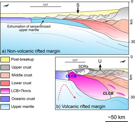
    Volcanic margins form part of large igneous provinces, which are characterised by massive emplacements of mafic extrusives and intrusive rocks over very short time periods (White & McKenzie, 1989; Holbrook & Keleman, 1993; Mjelde et al., 1997, 1998, 2002; Eldholm et al., 2000; Menzies et al., 2002). Volcanic margins are distinguished from non-volcanic margins (or “cold” margins, e.g. the Iberian margin) which do not contain large amounts of extrusive and/or intrusive rocks and may exhibit unusual features such as unroofed, serpentinized mantle (Boillot & Froitzheim, 2001)

    (Figure 1). Volcanic margins are known to differ from classical passive margins in a number of ways, the main ones being:
    • a huge volume of magma forms during the early stages of crustal accretion along the future spreading axis, typically as seaward-dipping reflector sequences (SDRs),
    • the presence of numerous sill/dike and vent complexes intruding the sedimentary basin,
    • the lack of strong passive-margin subsidence during and after breakup, and
    • the presence of lower crust with anomalously high seismic P-wave velocities (7.1-7.8 km/s) – so-called lower crustal bodies (LCBs) (Planke et al., 1991; Eldholm et al., 2000).
    (Figure 1) The high velocities (Vp > 7 kms) and large thicknesses of the LCBs are often used to support the theory of “hot” mantle plume involvement leading to the formation of a huge volume of magmatic rocks (White & McKenzie, 1989; Eldholm & Grue, 1994). LCBs are often lot cated along the continent-ocean transition but can extend beneath the continental part of the crust. 

    In the continental domain, there are fewer constraints on their nature and chronology. Better constraints of the timing of LCB emplacement, seismic velocities, size and geological context are pertinent to the plume/non-plume debate.

    Figure 1: Main characteristics of volcanic margins versus non-volcanic passive margins. (a) Schematic crustal section of a wide non-volcanic “Galician type” margin characterised by the progressive exhumation of the underlying seprentinized mantle (Boillot & Froitzheim, 2001). (b) Structure and main characteristics of a narrow volcanic “Vøring type” margin. CLCB: continental lower-crustal body; OLCB: oceanic lower-crustal body; SDRs: Seaward Dipping Reflector sequences. S symbolizes the post-breakup subsidence of the non-volcanic margin, U represents the relative uplift recorded along the volcanic margin as an isostatic consequence of thick high velocity underplating observed along the continent-ocean transition (COT).

     
    1.2. The outer Vøring Basin: a lower crustal window near the Tertiary lava flows

    (Figure 2) SDRs and LCBs have long been recognized along the NE Atlantic and particularly in the outer Vøring Basin. 

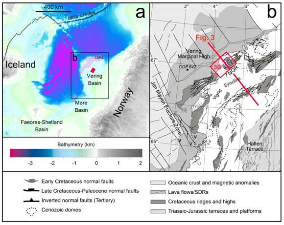
    (Figures 2, 3) The outer Vøring Basin is a complex system of faulted ridges defined at the base Tertiary unconformity level. It is located between a deep Cretaceous basin to the east and the Vøring Marginal High to the west near the ocean-continent transition (Lundin & Doré, 1997; Walker et al., 1997; Mjelde et al., 1997, 1998, 2002; Ren et al., 1998; Gernigon et al., 2003, 2004) 

    (Figures 2, 3) As part of the polyrifted system, the outer Vøring Basin was particularly affected by Late Cretaceous-Paleocene rifting leading to breakup and SDR emplacement at ~54-55 Ma 

    Figure 2: a) Bathymetric map of the Vøring Margin and location of the study area. b) Structural map of the outer Vøring Basin. Bathymetric data from Sandwell & Smith (1997). Red rectangle on b) represents the 3D seismic survey used for the investigation. Lava flows, SDRs, after Berndt et al. (2001). Modified from Gernigon et al. (2003).

    The Vøring Margin is particularly interesting because a huge amount of geophysical data exist (refraction, 2D/3D seismic) which has bearing on the shallow manifestation of both lithospheric and asthenospheric postulated processes (e.g. mantle plume and small-scale convection . It is also a good study area because relationships between magmatism, LCBs and the sedimentary basin can be investigated with confidence, as extrusive sequences are relatively narrow.

    (Figure 3) Here, we focus on the north Gjallar Ridge (NGR), which is located between the Vigrid Syncline and the Vøring Marginal High  (Lundin & Doré, 1997; Ren et al., 1998, Gernigon et al., 2003, 2004). 

    (Figures 4, 5) In particular, one of the most interesting features of the NGR concerns a mid-crustal dome-shaped reflection underlying the NGR, mapped regionally and named the T Reflection (Gernigon et al., 2004) . 

    Recent investigations suggest that the T Reflection demarcates the top of the continental LCB (Walker et al., 1997; Ren et al., 1998; Mosar, 2002; Gernigon et al. 2003, 2004). Earlier interpretations directly assigned the crustal dome beneath the outer Vøring Basin to magmatic underplating (T Reflection = top of the LCB = top of the Tertiary breakup-related underplating; Eldholm & Grue, 1994; Mjelde et al., 1997, 1998, 2002), or a metamorphic core complex triggered by underlying magma chambers (Lundin & Doré, 1997). 

    In this paper, we present and discuss the following aspects of the LCB:
    • the 3D geometry and geophysical properties of the crustal structure underlying the NGR,
    • the relation between the T Reflection, LCB and NGR structures,
    • the tectonic and temporal evolution of the NGR including issues related to lithospheric rupture, “mantle plume” theory and LCB emplacements, and
    • the controversial nature of continental LCBs and implications for understanding of the tectonics of volcanic margins and asthenospheric processes in general.
    2. Magmatism, LCBs and basin deformation: a structural approach

    2.1. The north Gjallar Ridge (NGR) and the T Reflection

    (Figures 3, 4) The T Reflection is observed in a large part of the NGR at the base Tertiary level (e.g. Lundin & Doré, 1997; Ren, 1998) . 

    (Figure 3) Gernigon et al. (2003) show that the T Reflection extends over a large part of the outer Vøring Basin, and is limited to the east by the Fles Fault Complex . 

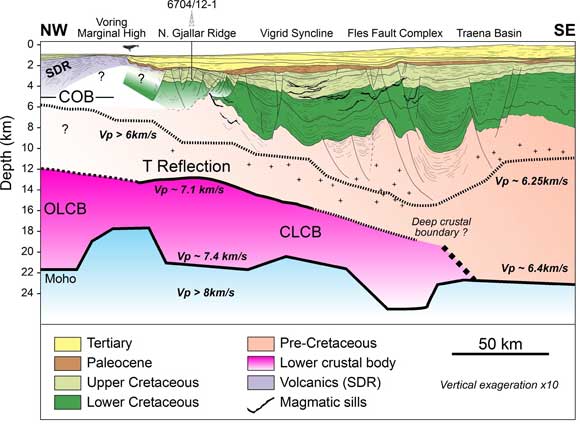
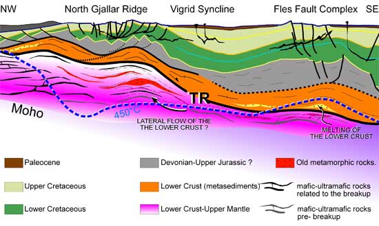
    (Figure 3) The 3D geometry of the T Reflection is now fully constrained on the NGR by 2D/3D seismic surveys, where it comprises a rounded feature 20 km in diameter with a thickness between 7 and 8 s two-way travel time. The T Reflection is shallower than the present-day Moho estimated from ocean-bottom seismometer (OBS) data to be at 20 km depth (Raum, 2000).

    Figure 3: Depth-converted cross-section of the outer Vøring Basin. The north Gjallar Ridge (NGR) is located close to the breakup volcanic rocks defined by the SDRs of the Vøring Marginal High. The T Reflection observed in 2D seismic data match the top of the lower crustal body (7 km/s) defined by Raum (2000).

    (Figure 4) The top of the T Reflection, repositioned in the OBS depth model, is at 13-14 ± 2 km depth. Ren et al. (1998) and Skogseid et al. (2000) also suggest that the top of the T Reflection lies between 10 and 15 km, matching the top of the continental part of the LCB.  

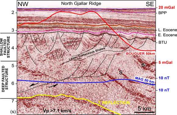
    Mjelde et al. (1997) and Raum (2000) suggest that the T Reflection marks the top of the interval with Vp > 7.1 km/s, and interpret it as the top of mafic/ultramafic underplated material, thereby invoking the underplating hypothesis. On the basis of geophysical observations Gernigon et al. (2004) show that the T Reflection represents a high-impedance boundary associated with a high-density body (with a high velocity contrast) but litle magnetic susceptibility. This does not favour a mafic/ultramafic origin .


    Figure 4: Reflection seismic line (from the NGR Saga 3D survey) showing the crustal structure of the NGR. The cross-line illustrates the rollover geometry of the NGR, defined by the base Tertiary unconformity (BTU) and controlled in depth at a decollement level. During the early Campanian-early Paleocene, extension at shallow depth is characterised by rollover geometry accommodated in depth by a detachment fault zone connected with the T reflection. S represents magmatic sills. After Gernigon et al. (2004). The blue curve represents the total magnetic field and the red curve represents the Bouguer gravity anomaly.

    2.2. Structural and tectonic evolution of the NGR 

    (Figures 4, 5 and Table 1) Different structural levels record different types of stretching during NGR evolution from rifting to breakup.
    • The upper level shows that syntectonic wedges and tilted blocks formed during early Campanian-Paleocene time (well calibration) and were accommodated at depth by a decollement layer within lower Cretaceous (Albian-Cenomanian?) shales. The shape of the dome defined by the T Reflection controls the fault patterns which mostly focus around the dome.
    • The middle level shows block structures (poorly imaged) cut by a large low-angle ductile shear zone at depth, which splays upwards into normal faults. Normal displacement along this low-angle shear zone is expected prior to breakup rifting in order to accommodate extension of the overlying tilted blocks.
       
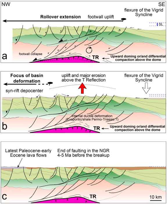
    • (Figure 5) The deepest level shows the updomed T Reflection. 
       
      The dome may have accentuated block rotation and low-angle faulting, in a similar way to the isostatic denudation and rolling-hinge process. Extension on low-angle faults is known to accommodate large amounts of crustal stretching in rifted basins. The deduction that low-angle shear zones exist in the deeper part of the NGR is not surprising since extension in the shallow part of the Cretaceous basin cannot accommodate the severe crustal thinning thought to have occurred just prior to lithospheric rupture .
    (Table 1, Figure 5) Faulting in the NGR is sealed at the erosive base Tertiary unconformity (uplift ~ 550-600 m), draped by Upper Paleocene-Early Eocene sediments. 

    This pre-breakup regional unconformity, which is observed all along the NE Atlantic, has been interpreted in terms of the Icelandic plume – lithosphere impingement hypothesis (regional uplift) proposed by Skogseid et al. (2000) to have occurred during the late Maastrichtian-Early Paleocene .
    • (Figure 5a)  Before the late Maastrichtian-Early Paleocene uplift, the NGR was already a structural high above the crustal dome.
       
      (Figure 5c) which was already in place before the breakup and the main volcanic event in Early Eocene time.
       
    • (Figure 5b) Faulting in the NGR stops before the Early Eocene breakup and reflects a progressive or sudden focus of the deformation toward the future breakup zone. This migration of deformation occurred from early to late Paleocene-early Eocene time.
    The early Paleocene also marks the onset of magmatism (NE Atlantic magmatic phase 1 of Saunders et al., 1997). This strongly suggests that early magmatic melts were most likely involved in the breakup process. The pre-breakup focus of extensional deformation may be interpreted as a result of weakening of the lithosphere (perhaps due to ponding, underplating and diking) as suggested by models showing that a melted zone within the lithosphere may strongly control the localization of stretching and necking (Geoffroy, 1998; Callot et al., 2002; 

    Table 1: Chronological synthesis of tectono-magmatic events from rifting to breakup.
    Periods
    Age (Ma)
    Tectono-magmatic events
    E. Campanian-E. Maastrichtian
    80-70
    Initiation of the late rifting phase (late Cretaceous-Paleocene)
    No evidence for magmatism
    E. Maastrichtian-L. Maastrichtian
    70-66
    Climax of late Cretaceous-Paleocene continental rifting
    Uplift and faulting along the North Gjallar Ridge.
    Latest Maastrichtian-Danian
    66-60
    Regional uplift of the NE Atlantic (plume?)
    Maximum (?) erosion of the Maastrichtian High located above the dome.
    Progressive focus of faulting toward the proto-oceanic axis
    First evidence of alkaline magmatism
    Selandian
    60-55
    Evidence of Late Paleocene sediment above most of the high previously eroded
    Latest Paleocene-Ypresian
    55-53
    Transient volcanism related to the breakup (C24)
    Second phase of uplift recorded in the North Gjallar Ridge
    E. Eocene-Mid. Eocene
    53-50
    Decrease in the magmatism & rapid relative subsidence

    Figure 5: Three-stage kinematic model for the evolution of the NGR from the early Campanian (~ 80 Ma) (a) to the latest Maastrichtian-Early Paleocene main uplift (~ 60 Ma), and (b) up to the final breakup in the latest Paleocene-earliest Eocene (~ 55 Ma). (c) Onset of magmatism in early Paleocene time that coincides with migration of the deformation toward the pre-breakup axis. The NGR was already influenced by the T Reflection (= top LCB) before the breakup and the first evidence of magmatism. This model suggests that the LCB beneath the NGR is a pre-preakup feature.

    3. Discussion: the origin of the LCB: a breakup/plume-related feature?

    3.1. LCBs and implications for the plume/non-plume debate

    (Figure 6) In the oceanic domain and along the continent-ocean transition LCBs most likely represent magmatic rocks but the significance of the continental LCBs beneath the rift zone of the outer Vøring Basin is controversial :
    • What do we really know about the geological meaning of the LCB?
    • Are continental LCBs really magmatic features?
    • Are LCBs fully representative of breakup-related underplating?
    • Do we necessarily need a mantle plume to generate underplating?
    • Do high P-wave velocities values really reflect hot mantle temperatures (picrites).
    What are the relationships between LCB, basin deformation and continental breakup? In the case of the NGR and volcanic margins in general, the answers to these questions could lead to a better estimate of the total amount of melt produced during breakup. 

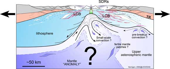
    (Figure 6) An improved volume estimate would have significant implications for quantification of mantle temperatures and dynamics, which are still poorly constrained
    .
    Figure 6: Conceptual cross-section along conjugate volcanic margins during breakup. Volcanism and underplating attributed to the whole LCB are due to complex interactions between lithospheric extension and controversial sub-lithospheric processes involving a mantle “anomaly”. The most popular hypothesis for continental breakup magmatism and SDR formation is the arrival of a mantle plume originating from the core-mantle boundary. The plume impact hypothesis attributes anomalous mantle melting to a “hot” thermal anomaly in convecting mantle. Alternative hypotheses involve small-scale convection and circulation of fertile and heterogeneous mantle that also result in a high degree of melting. 

    3.2. The meaning of the continental part of the LCB beneath the NGR: mafic underplating or not?

    Regional considerations show that the magmatic activity in the NE occurred throughout the entire Paleocene between 63 and 54 Ma with a peak at 50-55 Ma (Saunders et al., 1997). In view of the high-velocity character of the lower crust and its position close to the SDRs, a mafic/ultramafic interpretation was proposed by Mjelde et al. (1997, 1998) to explain the high Vp values observed along the breakup axis and below the NGR. 

    According White & McKenzie (1989), high-Mg underplated bodies characterised by high-velocity lower crust should be a consequence of the “Icelandic mantle plume” impingement on the base of the lithosphere. At ~ 65-60 Ma, this interaction is expected beneath Greenland located ~ 500-1000 km away from the study area (Lawver & Müller, 1994). 

    According to this “Icelandic mantle plume” model, direct thermal involvement of the Norwegian margin is not expected before Early Tertiary time.
    • If we assume that a significant amount of underplating requires the presence of a mantle plume, then the T Reflection and the LCB are unlikely to have originated from the top of the “Tertiary” magmatic underplated unit, since it is clearly demonstrated that they existed prior to the Paleocene.
    It is, however, not clear if picritic magmas are really related to high mantle temperatures . Sheth (1999), for reference, denounces the “basic fallacy of the surported picrite-plume connection …… obscure at best”. Picritic magmas do not necessarily characterise high-degree or high-temperature melts but could simply be explained by extensive decompression of an uprising mantle (active or passive) and later differentiation.

    Mjelde et al. (2002) suggest that the LCB in the Vøring Basin is decoupled from the breakup itself (oceanic/transitional LCB and continental LCB), and could be restricted to a process that occurred during the latest phase of rifting prior to breakup. This could mean that significant lower-crustal intrusions might have been formed during the Late Cretaceous. In this case, our evolution model of the NGR could be used as an argument in favor of quite significant Campanian-Maastrichtian (pre-breakup) underplating, trapped beneath the Vøring Basin.

    (Figure 6) Some geodynamic models can explain moderate amounts of pre-breakup magmatism without involving any mantle plume effect. Moderate temperature, fertile mantle patches (e.g. eclogites) in the upper mantle, and small-scale convection may explain significant pre- and syn-breakup melt production  (e.g. Boutillier & Keen, 1999; Anderson et al., 2000; van Wijk et al., 2001; Korenaga, 2002, 2004;
    • The T Reflection may represent the top of a significant pre-breakup (syn-rift?) underplating unit. Significant pre-breakup underplating may not be directly linked to a “hot mantle plume” but might result from other sub-lithospheric processes that interact with the rift system. However, if the LCB beneath the NGR really represent mafic material, the non-magnetic nature of the mid-crustal dome is difficult to explain.
       
    3.3. Alternative “non-magmatic” hypothesis

    Another geological model that may account for both the non-magnetic and high-velocity characteristics of the NGR lower crust is that this layer consists of pre-breakup crystalline rocks. The non-magmatic lower continental crust below the outer Vøring Basin is generally interpreted as granodioritic with P-wave velocities ranging between 6.5 and 7 km/s (Mjelde et al., 1997; 1998; Raum, 2000). However, it has been observed that the lower crust has locally higher velocities.

    Serpentinised mantle displays a large range of P-wave velocities, ranging between 5 and 7.5 km/s and high Vp/Vs values > 1.8 (O'Reilly et al., 1996). These values are quite similar to those observed below the T Reflection. 

    (Figure 1) The T Reflection may represent the top of a sepentinised mantle but such rocks are only expected to occur within highly stretched crusta . 

    Such environments are difficult to explain at depths of 12-15 km (decompacted depth without post-rift sediments laid down during the last stage of rifting) below the NGR. The presence of serpentinised mantle below the T Reflection has already been suggested by Ren et al. (1998). 

    The same assumption was recently published in Mjelde et al. (2002) based on Vp/Vs results and a discussion of the large-scale crustal stretching of the Vøring Margin.
    • The T Reflection may represent the top of a serpentinised mantle. However, the highly saturated water condition required for this process is questionable and needs further supporting evidence.
    Along the outer Vøring Basin, the LCB is limited to the east by the Fles Fault Complex (Figure 3) known to be a major zone of weakness active during the long tectonic history of the Norwegian margin (Doré et al., 1997). It cannot be excluded that the Fles Fault Complex may reflect a deep suture zone between different crustal terranes and this could also explain the velocity contrasts of the deep lower crust beneath the Vøring Basin. 

    Figure 8) High-pressure granulite/eclogitic material is known to have both high P-wave velocity (7.2-8.5 km/s) and high density (2.8-3.6 g/cm3; Fountain et al., 1994). These rocks are well documented in the eastern part of the Norwegian Western Gneiss Region, outcropping in the footwall of the Hornelen post-orogenic basin (Dewey et al., 1993.

    Its offshore continuation to the west has been recently deduced in the northern North Sea below the Triassic-Jurassic rift system (Christiansson et al., 2000) and in the eastern part of the Møre Basin (Olafsson et al., 1992). Unpublished Expanded Spread Profiles shot during the Elf Refranorge project (1983-1986) also demonstrate that the geophysical nature of the lower crust in the eastern part of the Vøring margin is characterised by high P-wave velocity values (> 7 km/s) less than 20 km from the Trøndelag Platform (e.g. Planke et al., 1991).These intermediate velocity values are also difficult to interpret either as magmatic underplated or serpentinised mantle because both features are generally focused close to the breakup axis. 

    The geophysical properties of the Caledonian nappes also display low magnetic succeptibilities and normal shelf-type thermal gradients (Olesen et al., 1997).
    • The LCB underlying the T Reflection may be partly (or fully?) explained as pre-existing high-velocity, non-mafic metamorphic rocks such as eclogites or migmatites. Most likely the T Reflection may represent an old (Caledonian-Paleozoic?) peneplanated surface.
       

    Figure 7: Crustal model proposed to explain the LCB along the outer Vøring Basin (at the Paleocene stage). Figure 8 (below) illustrates eclogite outcropping below the Devonian Hornelen Basin, onshore Norway.

    Figure 8: Eclogites (Hornelen Basin, Norway). L. Gernigon TFE field trip 2000.
    4. Conclusions
    • 3D seismic data and data from borehole calibrations reveal pre-breakup early-Campanian-Paleocene rifting event along the north Gjallar Ridge (NGR). The T Reflection represents the top of the continental part of an LCB.
       
    • The T Reflection influenced the structural development of the sedimentary basin at least 4-10 Myr prior to breakup. Our observations clearly demonstrate that the continental part of the LCB, imaged beneath the NGR was already in place before the main volcanic event and SDR emplacement.
       
    • A pre-breakup underplating hypothesis for the LCB is not fully excluded but direct involvement of an “Icelandic mantle plume” is not so obvious. If the crustal dome really represents significant pre-breakup underplating, other dynamic processes are required. However, a magmatic interpretation of the LCB does not explain its low magnetic susceptibility.
       
    • The LCB below the NGR is interpreted here to partly (or fully?) represent a high P-wave velocity crystalline basement of retrograde high- and ultra-high-pressure rocks (granulite/eclogite material). 
       
    • A non-magmatic interpretation of the LCB has major implications for estimates of the thermal history, mantle temperature and magmatic production along the Vøring volcanic rifted margin because the amount of mafic material emplaced could be 20-40% less than has been hitherto thought.
    Related Posts Plugin for WordPress, Blogger...