Abstract
High P-wave velocities (7.1-7.8 km/s) in lower crustal bodies (LCBs) imaged along volcanic margins are commonly interpreted as plume- and breakup-related thick mafic underplating. This interpretation is partially challenged in this paper on the basis of new seismic observations on the outer Vøring Basin (Norway).
An exceptionally strong reflection, the T Reflection, is particularly well defined below the north Gjallar Ridge (NGR). It is located near the volcanic traps formed during the NE Atlantic breakup (at ~55-54 Ma). The T Reflection coincides with the top of an LCB, forming a mid-crustal dome. Based on structural and temporal relationships, we show that the dome clearly influences the structural development of the NGR and predates the continental breakup by at least 10-15 Ma. We conclude that the continental part of the LCB observed beneath the outer Vøring Basin does not necessarily originate with an anomalous Tertiary magmatic event triggered by an “Icelandic mantle plume” (underplating). Instead we attribute it partly or fully to inherited, high-pressure granulite/eclogite lower crustal rocks in the continental domain.
Because the real amount of mafic material emplaced could be 20-40% less than is thought, this has major implications for the plume/non-plume debate.
1. The Outer Vøring Basin: a key area for understanding the lower crustal body (LCB) and relationship to the plume/non-plume question
1.1. Volcanic margins: general concepts
Volcanic margins form part of large igneous provinces, which are characterised by massive emplacements of mafic extrusives and intrusive rocks over very short time periods (White & McKenzie, 1989; Holbrook & Keleman, 1993; Mjelde et al., 1997, 1998, 2002; Eldholm et al., 2000; Menzies et al., 2002). Volcanic margins are distinguished from non-volcanic margins (or “cold” margins, e.g. the Iberian margin) which do not contain large amounts of extrusive and/or intrusive rocks and may exhibit unusual features such as unroofed, serpentinized mantle (Boillot & Froitzheim, 2001)
(Figure 1). Volcanic margins are known to differ from classical passive margins in a number of ways, the main ones being:
- a huge volume of magma forms during the early stages of crustal accretion along the future spreading axis, typically as seaward-dipping reflector sequences (SDRs),
- the presence of numerous sill/dike and vent complexes intruding the sedimentary basin,
- the lack of strong passive-margin subsidence during and after breakup, and
- the presence of lower crust with anomalously high seismic P-wave velocities (7.1-7.8 km/s) – so-called lower crustal bodies (LCBs) (Planke et al., 1991; Eldholm et al., 2000).
(Figure 1) The high velocities (Vp > 7 kms) and large thicknesses of the LCBs are often used to support the theory of “hot” mantle plume involvement leading to the formation of a huge volume of magmatic rocks (White & McKenzie, 1989; Eldholm & Grue, 1994). LCBs are often lot cated along the continent-ocean transition but can extend beneath the continental part of the crust.
In the continental domain, there are fewer constraints on their nature and chronology. Better constraints of the timing of LCB emplacement, seismic velocities, size and geological context are pertinent to the plume/non-plume debate.
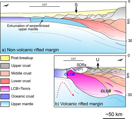
Figure 1: Main characteristics of volcanic margins versus non-volcanic passive margins. (a) Schematic crustal section of a wide non-volcanic “Galician type” margin characterised by the progressive exhumation of the underlying seprentinized mantle (Boillot & Froitzheim, 2001). (b) Structure and main characteristics of a narrow volcanic “Vøring type” margin. CLCB: continental lower-crustal body; OLCB: oceanic lower-crustal body; SDRs: Seaward Dipping Reflector sequences. S symbolizes the post-breakup subsidence of the non-volcanic margin, U represents the relative uplift recorded along the volcanic margin as an isostatic consequence of thick high velocity underplating observed along the continent-ocean transition (COT).
1.2. The outer Vøring Basin: a lower crustal window near the Tertiary lava flows
(Figure 2) SDRs and LCBs have long been recognized along the NE Atlantic and particularly in the outer Vøring Basin.
(Figures 2, 3) The outer Vøring Basin is a complex system of faulted ridges defined at the base Tertiary unconformity level. It is located between a deep Cretaceous basin to the east and the Vøring Marginal High to the west near the ocean-continent transition (Lundin & Doré, 1997; Walker et al., 1997; Mjelde et al., 1997, 1998, 2002; Ren et al., 1998; Gernigon et al., 2003, 2004)
(Figures 2, 3) As part of the polyrifted system, the outer Vøring Basin was particularly affected by Late Cretaceous-Paleocene rifting leading to breakup and SDR emplacement at ~54-55 Ma
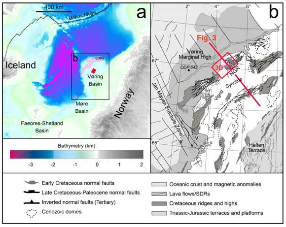
Figure 2: a) Bathymetric map of the Vøring Margin and location of the study area. b) Structural map of the outer Vøring Basin. Bathymetric data from Sandwell & Smith (1997). Red rectangle on b) represents the 3D seismic survey used for the investigation. Lava flows, SDRs, after Berndt et al. (2001). Modified from Gernigon et al. (2003).
The Vøring Margin is particularly interesting because a huge amount of geophysical data exist (refraction, 2D/3D seismic) which has bearing on the shallow manifestation of both lithospheric and asthenospheric postulated processes (e.g. mantle plume and small-scale convection . It is also a good study area because relationships between magmatism, LCBs and the sedimentary basin can be investigated with confidence, as extrusive sequences are relatively narrow.
(Figure 3) Here, we focus on the north Gjallar Ridge (NGR), which is located between the Vigrid Syncline and the Vøring Marginal High (Lundin & Doré, 1997; Ren et al., 1998, Gernigon et al., 2003, 2004).
(Figures 4, 5) In particular, one of the most interesting features of the NGR concerns a mid-crustal dome-shaped reflection underlying the NGR, mapped regionally and named the T Reflection (Gernigon et al., 2004) .
Recent investigations suggest that the T Reflection demarcates the top of the continental LCB (Walker et al., 1997; Ren et al., 1998; Mosar, 2002; Gernigon et al. 2003, 2004). Earlier interpretations directly assigned the crustal dome beneath the outer Vøring Basin to magmatic underplating (T Reflection = top of the LCB = top of the Tertiary breakup-related underplating; Eldholm & Grue, 1994; Mjelde et al., 1997, 1998, 2002), or a metamorphic core complex triggered by underlying magma chambers (Lundin & Doré, 1997).
In this paper, we present and discuss the following aspects of the LCB:
- the 3D geometry and geophysical properties of the crustal structure underlying the NGR,
- the relation between the T Reflection, LCB and NGR structures,
- the tectonic and temporal evolution of the NGR including issues related to lithospheric rupture, “mantle plume” theory and LCB emplacements, and
- the controversial nature of continental LCBs and implications for understanding of the tectonics of volcanic margins and asthenospheric processes in general.
2. Magmatism, LCBs and basin deformation: a structural approach
2.1. The north Gjallar Ridge (NGR) and the T Reflection
(Figures 3, 4) The T Reflection is observed in a large part of the NGR at the base Tertiary level (e.g. Lundin & Doré, 1997; Ren, 1998) .
(Figure 3) Gernigon et al. (2003) show that the T Reflection extends over a large part of the outer Vøring Basin, and is limited to the east by the Fles Fault Complex .
(Figure 3) The 3D geometry of the T Reflection is now fully constrained on the NGR by 2D/3D seismic surveys, where it comprises a rounded feature 20 km in diameter with a thickness between 7 and 8 s two-way travel time. The T Reflection is shallower than the present-day Moho estimated from ocean-bottom seismometer (OBS) data to be at 20 km depth (Raum, 2000).
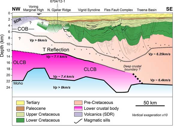
Figure 3: Depth-converted cross-section of the outer Vøring Basin. The north Gjallar Ridge (NGR) is located close to the breakup volcanic rocks defined by the SDRs of the Vøring Marginal High. The T Reflection observed in 2D seismic data match the top of the lower crustal body (7 km/s) defined by Raum (2000). (Figure 4) The top of the T Reflection, repositioned in the OBS depth model, is at 13-14 ± 2 km depth. Ren et al. (1998) and Skogseid et al. (2000) also suggest that the top of the T Reflection lies between 10 and 15 km, matching the top of the continental part of the LCB. Mjelde et al. (1997) and Raum (2000) suggest that the T Reflection marks the top of the interval with Vp > 7.1 km/s, and interpret it as the top of mafic/ultramafic underplated material, thereby invoking the underplating hypothesis. On the basis of geophysical observations Gernigon et al. (2004) show that the T Reflection represents a high-impedance boundary associated with a high-density body (with a high velocity contrast) but litle magnetic susceptibility. This does not favour a mafic/ultramafic origin . 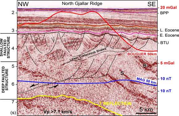 Figure 4: Reflection seismic line (from the NGR Saga 3D survey) showing the crustal structure of the NGR. The cross-line illustrates the rollover geometry of the NGR, defined by the base Tertiary unconformity (BTU) and controlled in depth at a decollement level. During the early Campanian-early Paleocene, extension at shallow depth is characterised by rollover geometry accommodated in depth by a detachment fault zone connected with the T reflection. S represents magmatic sills. After Gernigon et al. (2004). The blue curve represents the total magnetic field and the red curve represents the Bouguer gravity anomaly. 2.2. Structural and tectonic evolution of the NGR (Figures 4, 5 and Table 1) Different structural levels record different types of stretching during NGR evolution from rifting to breakup.
(Table 1, Figure 5) Faulting in the NGR is sealed at the erosive base Tertiary unconformity (uplift ~ 550-600 m), draped by Upper Paleocene-Early Eocene sediments. This pre-breakup regional unconformity, which is observed all along the NE Atlantic, has been interpreted in terms of the Icelandic plume – lithosphere impingement hypothesis (regional uplift) proposed by Skogseid et al. (2000) to have occurred during the late Maastrichtian-Early Paleocene .
The early Paleocene also marks the onset of magmatism (NE Atlantic magmatic phase 1 of Saunders et al., 1997). This strongly suggests that early magmatic melts were most likely involved in the breakup process. The pre-breakup focus of extensional deformation may be interpreted as a result of weakening of the lithosphere (perhaps due to ponding, underplating and diking) as suggested by models showing that a melted zone within the lithosphere may strongly control the localization of stretching and necking (Geoffroy, 1998; Callot et al., 2002; Table 1: Chronological synthesis of tectono-magmatic events from rifting to breakup.
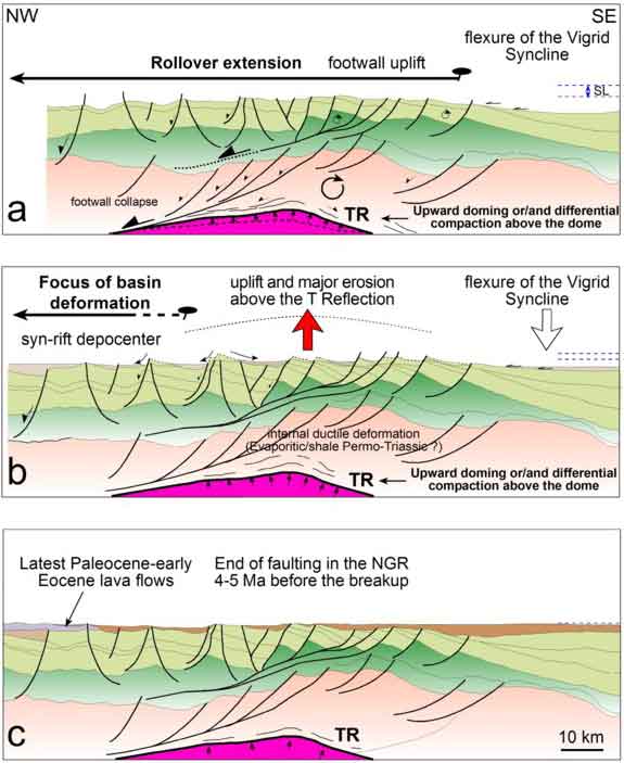 Figure 5: Three-stage kinematic model for the evolution of the NGR from the early Campanian (~ 80 Ma) (a) to the latest Maastrichtian-Early Paleocene main uplift (~ 60 Ma), and (b) up to the final breakup in the latest Paleocene-earliest Eocene (~ 55 Ma). (c) Onset of magmatism in early Paleocene time that coincides with migration of the deformation toward the pre-breakup axis. The NGR was already influenced by the T Reflection (= top LCB) before the breakup and the first evidence of magmatism. This model suggests that the LCB beneath the NGR is a pre-preakup feature. | |||||||||||||||||||||
3. Discussion: the origin of the LCB: a breakup/plume-related feature? (Figure 6) In the oceanic domain and along the continent-ocean transition LCBs most likely represent magmatic rocks but the significance of the continental LCBs beneath the rift zone of the outer Vøring Basin is controversial :
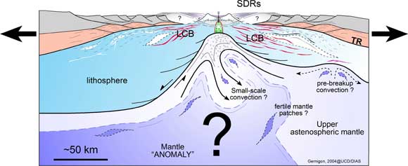
What are the relationships between LCB, basin deformation and continental breakup? In the case of the NGR and volcanic margins in general, the answers to these questions could lead to a better estimate of the total amount of melt produced during breakup. (Figure 6) An improved volume estimate would have significant implications for quantification of mantle temperatures and dynamics, which are still poorly constrained . Figure 6: Conceptual cross-section along conjugate volcanic margins during breakup. Volcanism and underplating attributed to the whole LCB are due to complex interactions between lithospheric extension and controversial sub-lithospheric processes involving a mantle “anomaly”. The most popular hypothesis for continental breakup magmatism and SDR formation is the arrival of a mantle plume originating from the core-mantle boundary. The plume impact hypothesis attributes anomalous mantle melting to a “hot” thermal anomaly in convecting mantle. Alternative hypotheses involve small-scale convection and circulation of fertile and heterogeneous mantle that also result in a high degree of melting. 3.2. The meaning of the continental part of the LCB beneath the NGR: mafic underplating or not? Regional considerations show that the magmatic activity in the NE occurred throughout the entire Paleocene between 63 and 54 Ma with a peak at 50-55 Ma (Saunders et al., 1997). In view of the high-velocity character of the lower crust and its position close to the SDRs, a mafic/ultramafic interpretation was proposed by Mjelde et al. (1997, 1998) to explain the high Vp values observed along the breakup axis and below the NGR. According White & McKenzie (1989), high-Mg underplated bodies characterised by high-velocity lower crust should be a consequence of the “Icelandic mantle plume” impingement on the base of the lithosphere. At ~ 65-60 Ma, this interaction is expected beneath Greenland located ~ 500-1000 km away from the study area (Lawver & Müller, 1994). According to this “Icelandic mantle plume” model, direct thermal involvement of the Norwegian margin is not expected before Early Tertiary time.
It is, however, not clear if picritic magmas are really related to high mantle temperatures . Sheth (1999), for reference, denounces the “basic fallacy of the surported picrite-plume connection …… obscure at best”. Picritic magmas do not necessarily characterise high-degree or high-temperature melts but could simply be explained by extensive decompression of an uprising mantle (active or passive) and later differentiation. Mjelde et al. (2002) suggest that the LCB in the Vøring Basin is decoupled from the breakup itself (oceanic/transitional LCB and continental LCB), and could be restricted to a process that occurred during the latest phase of rifting prior to breakup. This could mean that significant lower-crustal intrusions might have been formed during the Late Cretaceous. In this case, our evolution model of the NGR could be used as an argument in favor of quite significant Campanian-Maastrichtian (pre-breakup) underplating, trapped beneath the Vøring Basin. (Figure 6) Some geodynamic models can explain moderate amounts of pre-breakup magmatism without involving any mantle plume effect. Moderate temperature, fertile mantle patches (e.g. eclogites) in the upper mantle, and small-scale convection may explain significant pre- and syn-breakup melt production (e.g. Boutillier & Keen, 1999; Anderson et al., 2000; van Wijk et al., 2001; Korenaga, 2002, 2004;
3.3. Alternative “non-magmatic” hypothesis Another geological model that may account for both the non-magnetic and high-velocity characteristics of the NGR lower crust is that this layer consists of pre-breakup crystalline rocks. The non-magmatic lower continental crust below the outer Vøring Basin is generally interpreted as granodioritic with P-wave velocities ranging between 6.5 and 7 km/s (Mjelde et al., 1997; 1998; Raum, 2000). However, it has been observed that the lower crust has locally higher velocities. Serpentinised mantle displays a large range of P-wave velocities, ranging between 5 and 7.5 km/s and high Vp/Vs values > 1.8 (O'Reilly et al., 1996). These values are quite similar to those observed below the T Reflection. (Figure 1) The T Reflection may represent the top of a sepentinised mantle but such rocks are only expected to occur within highly stretched crusta . Such environments are difficult to explain at depths of 12-15 km (decompacted depth without post-rift sediments laid down during the last stage of rifting) below the NGR. The presence of serpentinised mantle below the T Reflection has already been suggested by Ren et al. (1998). The same assumption was recently published in Mjelde et al. (2002) based on Vp/Vs results and a discussion of the large-scale crustal stretching of the Vøring Margin.
Along the outer Vøring Basin, the LCB is limited to the east by the Fles Fault Complex (Figure 3) known to be a major zone of weakness active during the long tectonic history of the Norwegian margin (Doré et al., 1997). It cannot be excluded that the Fles Fault Complex may reflect a deep suture zone between different crustal terranes and this could also explain the velocity contrasts of the deep lower crust beneath the Vøring Basin. Figure 8) High-pressure granulite/eclogitic material is known to have both high P-wave velocity (7.2-8.5 km/s) and high density (2.8-3.6 g/cm3; Fountain et al., 1994). These rocks are well documented in the eastern part of the Norwegian Western Gneiss Region, outcropping in the footwall of the Hornelen post-orogenic basin (Dewey et al., 1993. Its offshore continuation to the west has been recently deduced in the northern North Sea below the Triassic-Jurassic rift system (Christiansson et al., 2000) and in the eastern part of the Møre Basin (Olafsson et al., 1992). Unpublished Expanded Spread Profiles shot during the Elf Refranorge project (1983-1986) also demonstrate that the geophysical nature of the lower crust in the eastern part of the Vøring margin is characterised by high P-wave velocity values (> 7 km/s) less than 20 km from the Trøndelag Platform (e.g. Planke et al., 1991).These intermediate velocity values are also difficult to interpret either as magmatic underplated or serpentinised mantle because both features are generally focused close to the breakup axis. The geophysical properties of the Caledonian nappes also display low magnetic succeptibilities and normal shelf-type thermal gradients (Olesen et al., 1997).
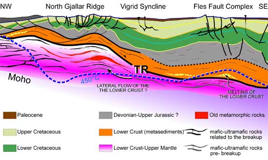 Figure 7: Crustal model proposed to explain the LCB along the outer Vøring Basin (at the Paleocene stage). Figure 8 (below) illustrates eclogite outcropping below the Devonian Hornelen Basin, onshore Norway. 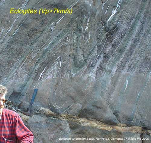 Figure 8: Eclogites (Hornelen Basin, Norway). L. Gernigon TFE field trip 2000. | |||||||||||||||||||||
4. Conclusions
|
